Selasa, 06 Maret 2012

Developer's Corner: ImageIO-Ext 1.1.3 Release is available


Dear all,
We would like to take the occasion to introduce the ImageI/O-Ext 1.1.3 release (which is now supported by GeoServer 2.1.x, 2.2.x and GeoTools 2.7.x and 8.x.

Various improvements have been implemented for the GDAL framework in order to enhance its speed and robustness:
  • Tested with GDAL 1.7.3 and 1.8.1 on all Linux32/linux64/win32/win64
  • More aggressive caching of GDAL Dataset resulting in more speed
  • Less synchronization around GDAL calls resulting in more scalability

Artifacts Released
Artifacts for Imageio-Ext have been deployed on the GeoSolutions maven repository, as well as on the OSGEO one.


The GeoSolutions team,

Rabu, 29 Februari 2012

Articolo di GeoSolutions su GeoServer ad ASITA 2011

Salve a tutti,
con colpevole ritardo, mettiamo a disposizione dei nostri lettori l'articolo presentato alla conferenza ASITA dell'anno scorso.
Una versione in pdf può essere scaricata qui.

The GeoSolutions team,

Selasa, 21 Februari 2012

GeoSolutions Enterprise Services: Open Source ed Enterprise si incontrano


  • Sei alla ricerca di supporto professionale high-end per affiancarti e guidarti nella creazione di una SDI basata su framework Open Source?
  • Stai disegnando una infrastruttura per OpenData e ti stai chiedendo se legarti al software proprietario sia la strada migliore?
  • Sei stufo di spendere tutto il budget in licenze senza riuscire a creare la infrastruttura di cui avresti bisogno?
  • Vorresti integrare una SDI  proprietaria con software Open Source?
GeoSolutions è la soluzione!

I piani di supporto offerti da  GeoSolutions  offrono l’opportunità di creare una SDI di classe Enterprise basata su framework Open Source geospaziali di comprovata affidabilità, fra i quali GeoServer, GeoNetwork e MapStore.

Con GeoSolutions  è semplice avvicinarsi al mondo Open Source dimenticando le licenze e decidendo autonomamente il budget da investire per il prodotto che si sta cercando! I nostri piani di supporto sono disponibili in diversi tagli, perché abbiamo pensato  a chi ha esigenze e budget contenuti ma anche a chi  deve gestire infrastrutture complesse e necessita di un supporto costante altamente specializzato.

Fatti supportare da chi ha creato il software che ti serve!

Visita il nostro sito per saperne di più e chiedici di contattarti, insieme discuteremo di quanti utenti possiamo supportare con le risorse di calcolo a disposizione piuttosto che del numero di licenze che dovresti comprare!

The GeoSolutions team,

Selasa, 31 Januari 2012

Developer's Corner: First Official Release of GeoNetwork-Manager library

During our work we support many clients with their GeoNetwork  installations, as a consequence we have found ourselves many times in the position to perform massive operations on metadata, e.g. when ingesting data in real-time via GeoBatch or when importing existing metadata in batch. In the past we have noticed that we were de-facto reusing and growing a small but useful codebase of common methods to interact with GeoNetwork therefore we decided to share them with the world (yeah, we are a bit ambitious :) ) and therefore we created the geonetwork-manager project for this purpose.

geonetwork-manager  is a Java library for interacting with GeoNetwork programmatically. It uses the GeoNetwork's admin services for the backend communication part, but the HTTP machinery  is completely hidden by the  geonetwork-manager  API itself. Last but not least  geonetwork-manager  is released under the MIT license. By the way, release 1.0 has just been cut and can be found on our maven repository.

In case you are interested in having support for your GeoNetwork installation, Talk to us first!
The GeoSolutions team,

Senin, 30 Januari 2012

Developer's Corner: Introducing Database Level Security in GeoServer

During our work we support manu GeoServer Enterprise installations which pull data from a spatial database of some sort, normally via a connection pool, a tool that keeps database connections around so that we don't have to open and close them at every request (something that could be very expensive).
The pool accesses the database via a shared user, that all GeoServer requests end up using. Some requests only require data reading (WMS GetMap), others modify data (WFS Transaction), some even create new tables (RESTConfig data uploading for example).
The pool user must be able to perform all and any of the operations that GeoServer needs, meaning that more often than not it has very wide powers of what it can do on the database.

GeoServer built in security, as well as extensions such as GeoRepository, allow to control what specific users can do and shield the database from security issues.
However in some enviroment the preferred security management policy is to have security restrictions operate at the database level instead, with the pool user being given minimal rights (normally, to list and describe the tables, but without any actual access to them). This has some advantages:
  • the security is setup just once for the variety of applications that might access the database
  • each user can actually perform only the operations that he/she was allowed to, regardless of eventual bugs/security holes in the application level software
  • leverages the DBA expertise
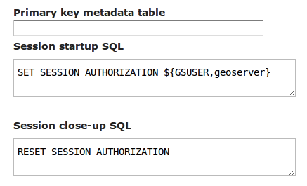
GeoSolutions recently implemented the ability to use DBMS session startup and teardown scripts that can be used to alter the user accessing the database for the duration of the current request, turning back to the pool user when the request is complete.
These commands can be specified in the configuration User Interface while setting up the data store. For example, if we wanted to have each and every PostgreSQL session use the credentials of the current GeoServer user we'd use the following setup:

Different databases will of course use different commands, or custom, in house package calls, to setup the current session user. See the GeoServer documentation for more details on how this new functionality can be used.

We'd like to thank Astrium GEO-Information Services for sponsoring this improvement and sharing it with the GeoServer and GeoTools communities.

Application security is certainly one of the topics we like to deal with. There is of course a lot more to explore and improve, this topic is both rich and interesting. Want for example CAS or Shibboleth security in your GeoServer intallation? Maybe integration with Active Directory? Talk to us first!

The GeoSolutions team,

Kamis, 26 Januari 2012

Improving GeoServer SQL Server support

Dear All,
in recent times we were hired to improve GeoServer SQL Server support story.

The SQL Server store was created and maintained during spare time by Justin DeOliveira, however due to lack of production usage, and work time to pour on it, it failed to reach to the same level of robustness and speed as the best supported stores, such as Oracle and PostGIS.

Our work this week tried to close this gap with a number of little and big improvements that make the code run faster and in a more reliable way:
  • add support for connection validation (very important for SQL Azure, which is very keen on closing pooled connections in your face)
  • use binary encoding, instead of text, to transfer geometries from the database
  • support for data paging at the database level
  • make sure the rich database test suite we have in GeoTools is fully implented for SQL server, ensuring good support for use cases such as dynamic SQL views, proper date/time encoding in filters, and the like, both on the development series and on the stable series
Our develoment focused on testing the code against both SQL Server 2008 and SQL Azure. SQL Azure is the SQL database one can use in the Microsoft Azure cloud system: while it does look a lot like SQL Server 2008, it does not quite behave the same way in all cases, and requires a specific JDBC driver to work properly.

There are still some improvements missing on the table, such as geography columns support, but we're sure you'll be able to get more out of a production usage of GeoServer and SQL Server now.

Interested in sponsoring further improvements? Looking for professional support service that deliver for your group? Let us know!

The GeoSolutions team,

Senin, 23 Januari 2012

GWT-OpenLayers release 0.7

Dear All,
we would like to inform you that the new release 0.7 for the GWT-OpenLayers project is available.

The releases is ready for the download and can be found here.

Notable improvements with this release are as follows:
  • Upgrade to GWT 2.4.0
  • Support to Google Maps V3
  • Improved source code formatting
  • Added and fixed several base methods and bindings such WMS Params, Layer methods
Alessio Fabiani has taken care of the 0.7 release as an active committer and administrator of the project.
We would like to thank all the other committers for their dedication and hard work!

Regards,
the GeoSolutions Team.